

 Payroll Mine Aerial PhotoPayroll Mine (Google Earth) |
|---|
 Payroll Mine 7-10-16Payroll Mine Foundations as observed on 7-10-2016. |
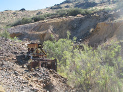 Payroll Mine MachinerySmall piece of machinery from a time gone by when the mine was active. 7-10-16 |
 Payroll MineCollapsed Adit to an old Mine Tunnel located at the Payroll Mine 7-10-16. |
 Payroll MineThis portal is located at the Payroll Mine. It is only about 10 to 12 feet in depth. Upon visiting in July of 2016 it appeared someone had been living in the tunnel at a more recent time with couch cushions for bedding. |
 Payroll MineView of the mine area looking down from the upper workings. My trusty steed is present in the center of the photo. |
 Payroll MineOldcConcrete footings near a shaft at the upper workings of the mine. It is near the shaft which is filled with water about 25 feet down. |
 Payroll MineA tripod is present next to the mine shaft at the Payroll Mine with a small bucket attached to a strap. It appears that someone has been collecting water from the mine. |
 Payroll MineThis photo shows the saft at the upper workings with the more recent water bucket in the foreground to the left. (7/10/16) |
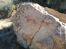 Payroll MineThis large rock was located near the upper mine shaft and had several drill holes. I am not sure why holes were drilled in this rock but I found it interesting. Note the crack in teh rock. (7/10/16) |
 Payroll MineThis was an interesting find off the side of the trail on a large rock. The axe head was very rusty and the handle was long gone. I left this for others to discover and hopefully followers in my footsteps will do the same. |
Payroll Mine - Mohave County
Where: Cerbat Mountains Near Chloride Arizona
Travel Conditions: Travel to this location requires a high clearance 4WD vehicle
Operation Dates: Discovered in 1887 and worked on and off through 1948.
Mining District: Wallapai District
Description: The Payroll mine is located about 1.5 miles from Chloride Arizona at about 4500 feet in elevation. Workings in the area started in 1887 when discovered by J. W. Murphy. The mine is located in a canyon called Payroll Gulch with the main production coming from a 600 foot shaft and some smaller tunnels. Early works in the area were for gold along the Payroll Vein. Later development in the 600 foot shaft consisted of workings at the 50, 200, 400, and 600 foot levels. The workings at these levels followed southeastward following the vein. The total workings of the drifts is estimated at 2000 feet.
The mine was worked from 1887 through 1907 when it closed the first time. Later the mine was reopened in 1916 and closing again in 1929. The mine was owned by the Pay Roll Mines Inc. during its later production years and ultimately closed in 1948.
What you will see today: There is a gate at the entrance of the canyon to the mine that was open on my visit. No trespassing is painted on a large rock just to the right of the gate. There was a lock hanging on the open gate that looked to be newer but the gate was open.
As you approach the mine there are foundations present on the hillside from an old processing plant. The area is getting overgrown by brush in some spots. A very short tunnel about 8 to 10 feet in depth is located along northwestern wall of the canyon. It appears that someone was using this short tunnel for a living space at some time based on some cushions on the tunnel floor and a 2 liter bottle of water in the tunnel.
There is some sort of small metal I-beam structure with a drum moving further up the canyon. Off to the right a little higher on the hill is a small tripod with a rope hanging from the end. Approaching this fixture there was a small bucket hanging on the rope. It was a pail that was not very old. Puzzled by this, I approached and found a mine shaft that was fenced off and I could only see for a short distance from the fence into the shaft as the darkness lower in the shaft would not allow me to see very far. Tossing a rock into the shaft, I discovred the shaft was full of water not to far beyond the shadows. My assumption is the bucket was used to bring water up from the mine shaft as it was only large enough to hold around a gallon of water.
There are some interesting structures where the old processing plant is located on the hillside. It would be interesting to review the concrete footers a little closer but it was a very hot time of the year during even though my visit was in the late morning. Further exploration of this area in cooler temperatures would be much better. At a later date I will have to see if I can still get past the gate to do more exploration
Comment: There are some interesting concrete structures from the old mill but so far I have not found any photos from the operation dates. Further investigation of this area in cooler weather is needed.
There was a no tresspassing singn painted on the rock at the gate but the gate was open. This may be an active claim and should be approached with caution and respect. Several liter bottles filled with water were noticed while walking around the mine area. This may be from someone that has a claim on the property or a transiant. As always, approach with caution and respect as you are a visitor.
Minerals Mined: Silver (Primary), Lead, Gold, Zinc, Copper, Molybdenum
People: Thomas B. Scott, J. W. Murphy
Acknowledgement: Minedat.org, USGS bulletin 0978e