
 Rainbow Mine Ariel ViewAriel View of the Rainbow Mine |
|---|
 Rainbow Mine 5-13-18 (34) |
 Rainbow Mine 5-13-18 (33) |
 Rainbow Mine 5-13-18 (13) |
 Rainbow Mine 5-13-18 (14) |
 Rainbow Mine 5-13-18 (10) |
 Rainbow Mine 5-13-18 (26) |
 Rainbow Mine 5-13-18 (30) |
 Rainbow Mine 5-13-18 (31) |
 Rainbow Mine Layout_edited |
 Rainbow Mine 1940Rainbow Mine - Photo from Mines of Mohave County Roman Malach |
Rainbow Mine - Mohave County
Where: Located in the Cerbat Mountains about 4 miles outside Chloride, Mohave County
Mining District: Wallapai Mining District
Travel Conditions: Dirt road that is in pretty good condition and passable by a pickup, Jeep or ATV
Operation Dates: Discovered in 1883 and operated intermittently until 1941
History: The Rainbow Mine was discovered in 1883 about 2 miles east of Chloride in the Cerbat mountain range. It operated intermittently until 1941 producing gold, silver, lead, and copper. Ore from the Rainbow Mine was transported to Chloride along a 9,000 foot long aerial tramway. From Chloride the ore was transported to smelters by train for processing. Reported production from the Rainbow Mine was reported at 2,400 ounces of gold, 34,952 ounces of silver, 4,748 pounds of copper, 313,271 pounds of lead and 22,420 pounds of zinc.
The tramway that served the Rainbow Mine was built about 1920 and extended 8,000 feet to a loading terminal near the Tennessee Mine. Robert Trennert described the Rainbow Mine Tram as having little documentation: “Although little documentation exists, a description of the ruins indicates that it was an “Automatic Aerial Tramway” built by the Interstate Equipment Company of New York. At the time, Interstate had just introduced a distinctive new design. This system featured cars, much like mine cares, mounted on four grooved wheels which rode on two parallel cables and were pulled by a traction cable attached directly to the bottom of the ore car. This three cable arrangement offered more stability, with the ore cars discharging their contents at the terminal and returning to the mine upside down on ta second line which usually ran below the first one. It is not known how long this line operated before being abandoned.”
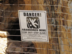
What you will see today: At the mine location there is two sets of tailings in the canyon. On the west side of the canyon there is a tunnel that is fenced off with a Danger sign on the fence. This tunnel follows a fissure in the rocks and has shafts in the floor at the entrance. These shafts have old wooden walkways across them and I would not trust the structure to walk on hence the "Danger" sign.
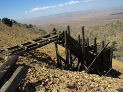
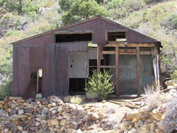
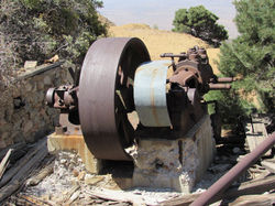
The East side of the mine has an old miners building, some concrete foundations, two ore bins, and an old compressor with a drive pulley. There is a mine shaft located by the upper ore bin with the old wooden headframe collapsed and scattered around the mine shaft. (May 13, 2018)
Comments: This is an interesting place to visit but caution is needed when walking around the old mine area not only for the mine danger but nails prortruding from the old timbers require close attention when walking around. There is a great view of the valley overlooking Chloride from the mine site.
Minerals Mined: Gold, Silver, and Lead
People: Erin Sherman - Discovered Rainbow Mine
Acknowledgement: Mines of Mohave County by Roman Malach, Aerial Mine Tramways in Arizona by Robert A. Trennert 1998, Google Earth